Shahdad is one of the oldest cities in Kerman Province, and Shahdad’s cloches are world-famous.
In addition to Iranians, many foreign tourists travel to Iran to see the kuluts, which are part of the Loot Desert.
In the land of the kaloot, a soft wind whispers in the ear, inviting one to admire the dignity of the lute.
If you are among the culottes at sunrise or sunset, it is impossible not to admire this wonder. As the sun sets, the stars slowly appear, transforming the black expanse of the sky into the most beautiful picture in the world. At night, you can easily immerse yourself in the sky of the culottes and pick out stars. Standing on the heights of these culottes, reality and fantasy merge, time and space are lost, creating a profound and unforgettable experience.
Kerman has many different attractions in addition to its historical monuments. The Nebkas, dense forests of Baft and Rubber, the heights full of tulips and rose gardens in Bardsir County, the Mediterranean valley of Delfard in the south of the province, and the forests of Mahur. But the Shahdad caves are one of the wonders and most important tourist and nature tourism attractions in this province, which when viewed from afar, remind you of an ancient and abandoned city.
What is a kaloot?
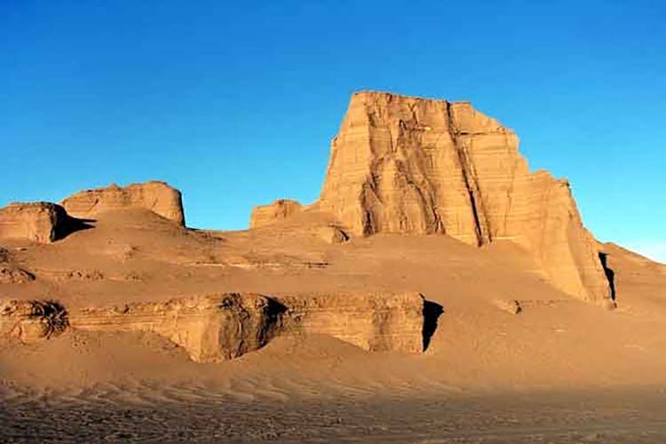
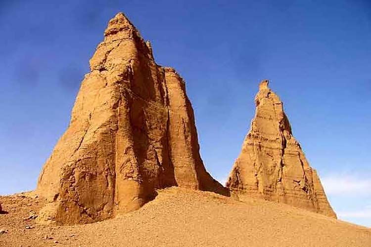
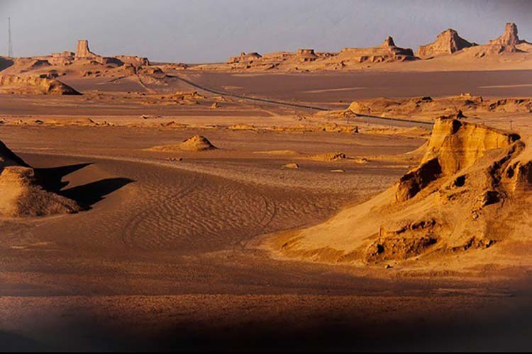
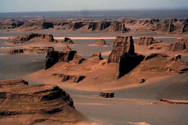
Kaloot is the name of a natural and geographical feature in the Loot Desert of Iran, which was created by the amazing mechanism of water and wind and land erosion about 20,000 years ago. Kaloot is a unique phenomenon and one of the most magnificent scenic and natural areas in the world. This megacity of mounds in the world is 80 kilometers wide and 145 kilometers long. It covers an area of more than 11,000 square kilometers and is located in the heart of the Loot Desert. Kaloot is a very amazing monument. The word Kaloot is made up of two parts: “Kal” and “Loot”, “Kal” means city and settlement, and “Loot” means naked.
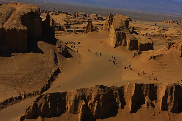
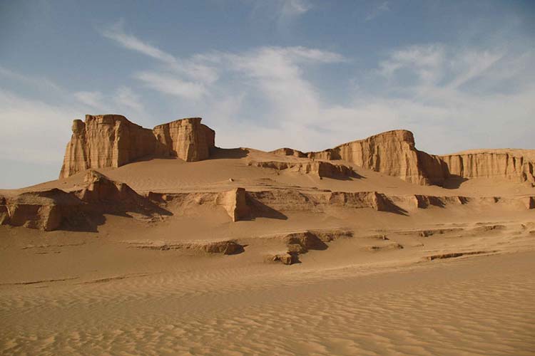
When you first pass through this area and see the culverts, you feel that humans have played a role in their construction, but in fact, the culverts, which are called “yardangs” in scientific terminology, are structures made by nature. Simply put, wind and water are the most important factors in the formation of the culverts. The bedrock of the kaloots is eroded by sand and sand winds, and its loose elements collapse under the pressure and turbulence of the wind over time, and the culverts are slowly formed. The culverts are unique in the world in terms of their rugged shape and the conditions of their formation, and there are countless mysteries about the principles and properties of their formation. When we look at the culverts from a distance, they resemble a large city with many skyscrapers, which has led some foreign tourists to refer to it as a “ghost city.”
In the Shahdad desert, there is a 100-hectare salt flat in the shape of a boiled egg, which is unlike any other place in the world. No one lives in this city, and everything is full of silence and peace. Passing through this city, despite its pristine natural beauty, it evokes a beautiful terror in the eyes and hearts of every passerby.
The kaloots are about 145 kilometers long from north to south and nearly 70 kilometers wide from west to east, and are located parallel to the huge sand dunes of eastern Lut, but the kaloots are more unknown, more dangerous, and more legendary than the sand dunes of eastern Loot. No one has ever crossed them, and what is said about them is based on the opinions and studies of scientists.
They say that every rain that falls on the Loot Desert creates a new face for the desert. Another factor was involved in the beautiful architecture of the kaloots: a river called Shor, a river that flows deep in the driest regions of Iran. Of course, this river is probably not salty and becomes salty because it passes through the desert. It is this river that has had a sufficient effect on moistening the walls of the culverts and facilitating their erosion.
The Shor River is the only permanent river that flows deep in the Lut Desert and is full of water throughout the year. The Shur River originates from the mountains northwest of Birjand. This river, which is one of the saltiest waters in the world and contains the most mineral salts, calms down after traveling approximately 200 kilometers to the southeast, near Shahdad and in an area called the Salt Mine Pit, which the locals call the Salt Pit. The salt hexagons created around the salt lake are another natural attraction of Lut. The existence of this river plays an important role in the relative strength and stability of the culverts.
Vegetation of the kaloots
From the Sirch Mountains towards the Kaluts, plant life decreases. Gaz trees can be seen scattered along the paths. At the edge of the kaloots, gazania bushes are placed on sand pots called nebka. This area is the end of the vegetation boundary, and within the channels that enter the culverts, scattered bushes of astragalus can be seen, which disappear as they advance into the culvert. From the foot of the kaloot to the east, no plant life is visible inside the culvert holes or on the culverts.
The lack of plant life in the culvert cannot be attributed to the type of soil and the salts present in it, because the soil in the culverts is made up of clay, sand, and salt. The soil type is not significantly different from the settlements and agricultural lands on the outskirts of Kalut. Of course, soil salinity is higher in the culverts, but this salinity cannot prevent the growth of halophyte plants. Water scarcity cannot be the cause of the lack of plant life in this area, because floods from the surrounding mountains flow inside the gullies, apart from the annual rainfall. The lack of vegetation in an area of this size can only be due to the strong winds that blow from time to time. These winds tear any plant roots from the ground and prevent the plant from growing.
The City of Loot: From Legend to Reality
Kaloot is considered the remains of a cursed and ruined city. It is stated in the books of early Islamic geographers that the remains of a ruined city can be seen at the foot of Kaloot. In the south of Kaloot, numerous bronze and pottery objects have been found. This old residential area is several kilometers long and wide. Given the climatic conditions and the impossibility of forming human gatherings, it is believed that these objects belong to an ancient city.
Archaeological studies on the discovered artifacts indicate that they date back to the second and third millennia BC. What is important about this discovery is that these artifacts were found amidst the clay and salt formations that shaped Loot. This means that the desertification of this region took place in ancient times, and it is likely that human settlements in this region were destroyed due to its desertification. An examination of the remains shows that this human formation was destroyed by a sudden event. The traces of the torrential movements of water on the bodies of the culverts indicate devastating floods in this region.
Perhaps the city was completely destroyed and buried among the rubble as a result of a massive flood that brought mud, salt, and desert chalk with it. What emerges from historical narratives and the works of geographers is that in the past, great civilizations existed in this region and were destroyed for some reason, and the legend of the city of Lut became popular for this reason. Whenever the city of Lut is mentioned, there is an image of ruined towers and houses that were created by wind erosion and, from a distance, resemble a ruined city. Perhaps the truth is that the city of Loti existed in the past and then disappeared, leaving a name for it in the minds of the people. In order to identify it, wherever the shape of a cloche is seen, it is called the city of Lot.